

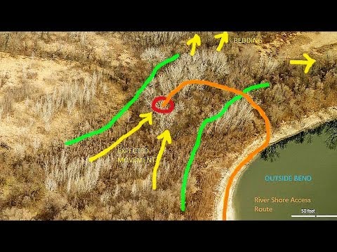
Ever wonder how a Navy SEAL or Army Ranger would plan a hunt? Long before they pick up a rifle, they sit down with a computer and sift through detailed satellite images to plan ingress and egress from an area of operations. They determine where to expect problems and find ways around them. Then they use GPS to accomplish the mission. Now, you can use those same techniques with non-classified technology to improve your chances in the field.
This video gives you detailed, how-to instructions to locate hunting areas, determine the best places to find game, and use your GPS to get there. Pay particular attention to how to overlay satellite imagery onto your GPS.
Other helpful stories you’ll like:
LocaCarnivore Expert: Best Deer Hunting Cartridges (New Study)


